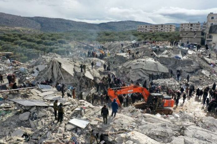
A combination of factors made the powerful earthquake that struck Turkey and Syria early Monday particularly deadly, including its timing, location, relatively quiet fault line and the weak construction of the collapsed buildings, experts said.
More than 2,300 people have been killed by the 7.8-magnitude quake near Turkey’s Syrian border, with the toll expected to grow as aftershocks reverberate throughout the day.
The earthquake caused such devastation partly because of its power—it is the strongest earthquake to hit Turkey since 1939—and because it hit a populated region.
Another reason is that it occurred at 04:17 am (0117 GMT), which meant that sleeping people were “trapped when their houses collapsed,” Roger Musson, honorary research associate at the British Geological Survey, told AFP.
The construction of buildings was also not “really adequate for an area that’s susceptible to large earthquakes,” said the author of the book “The Million Death Quake”.
That could partly be due to the fact that the fault line on which the earthquake struck has been relatively quiet recently.
Turkey is in one of the world’s most active earthquake zones. A quake along the North Anatolian fault line in the northern Turkish region of Duzce killed more than 17,000 people in 1999.
But Monday’s earthquake occurred on the other side of the country, along the East Anatolian fault.
The East Anatolian fault has not had a magnitude-7 quake for over two centuries, which could mean people were “neglecting how dangerous” it is, Musson said.
Because it had been so long since the last big quake, “quite a lot of energy” may have built up, Musson theorised.
The strength of the aftershocks on Monday, including a huge 7.5-magnitude tremor, supported this theory, he added.

‘Rerun’ of 1822
This earthquake was “almost a rerun” of a 7.4 magnitude one in the same area on August 13, 1822, Musson said.
It caused “an enormous amount of damage, whole towns in ruins, and casualties in the tens of thousands,” he said.
Aftershocks from that quake continued to rumble until June the following year.
The epicentre of Monday’s earthquake was at a relatively shallow depth of about 17.9 kilometres (11 miles) near the Turkish city of Gaziantep, which is home to around two million people.
It was caused by the Arabian tectonic plate moving northward, “scraping past Turkey,” Musson said.
“Because it cannot move smoothly, it sticks,” he said.
“The release of that movement along the fault is what produces a major earthquake like the one we’ve had today.”
Musson emphasised that the epicentre of such an earthquake was less important than how far the rupture extended along the fault line—in this case, around 100 kilometres (62 miles).
“This means that anywhere within the 100 kilometres along the trend of the fault is effectively right on top of the earthquake,” he said.

‘Patchy’ infrastructure
Carmen Solana, a volcanologist at the UK’s Portsmouth University, said that because earthquakes cannot be predicted, tremor-resistant buildings were crucial in affected areas.
“The resistant infrastructure is unfortunately patchy in South Turkey and especially Syria, so saving lives now mostly relies” on efforts to rescue survivors, she added.
In response to the 1999 earthquake, Turkey’s government passed legislation in 2004 mandating that all new construction met modern earthquake-proof standards.
Turkish President Recep Tayyip Erdogan made strong construction into a political priority after another quake struck the Aegean coast in 2020, killing 114 people.
Joanna Faure Walker, head of the University College London’s Institute for Risk and Disaster Reduction, called for Turkey to check whether the legislation had been adhered to in light of the latest disaster.
She also urged Turkey to review “whether there is possibility to improve the safety of older buildings”.
Bill McGuire, a volcanologist at University College London, said that “in Syria many structures have already been weakened by more than a decade of war”.
© 2023 AFP.

